Land Registry Plans
Boundary Surveys & Disputes
Conveyancing & Lease Plans
Boundary Surveys
Boundary surveys & plans are undertaken in accordance with Land Registry guidelines and generally become part of a properties deeds. They can be used to register land with Land Registry, define a boundary line between two plots or sub-divide a single plot. They can also be used to define rights of way and easements over land belonging to others. The plans can be annotated with measurements to the boundary line from existing structures or be related to GPS derived national grid coordinates if required.


Land Registry General Boundaries
Many land owners are surprised to discover that Land Registry title plans do not define the exact line of a boundary. They are very often based on O.S. mapping that uses a single line to delineate a boundary feature that may be several metres wide (such as a hedge) and are also subject to the O.S. accuracy which is defined as 1.0m for urban areas and 2.5m for rural areas. The plans only give an approximation of the location of boundary's and are therefore referred to as showing general boundaries.

Determined Boundary Plans
Unlike a general boundary plan, a determined boundary plan defines the exact location of a boundary by providing precise reference measurements to physical features on the site or by providing coordinates referenced to O.S. national grid. They are often produced at the conclusion of a boundary dispute (see below) but can be requested so that two land owners can be sure of where their boundary lies. Determined boundary plans can be lodged with Land Registry, but it is important that both parties to the boundary are in agreement before this is done.
Boundary Disputes
Boundary disputes can arise for all sorts of reasons. Someone might erect a new fence that looks to be in the wrong place, there may be no deed plan that adequately defines a boundary between two plots of land, someone might brazenly do a land grab and annex a portion of land hoping their neighbour wont notice or kick up a fuss.
The process of resolving a boundary dispute will often start with an accurate survey and then an analysis of historic documents such as property deeds. Historic plans drawn to a recognised scale with dimensions appended are the most useful documents although sometimes descriptions of the boundaries in

conveyancing documents can give clues as to where the boundary lies. If these do not exist then the only option is to look at what is on the ground and work out who owns the boundary features, such as walls, hedges, fences etc so that a fair and considered alignment for the boundary is reached. This process is made a lot easier if the landowners are involved and it is important to understand that compromise is often required on both sides.

Lease Plans
A lease is a legally binding contract outlining the terms under which one party (the tenant) agrees to rent property owned by another party. It guarantees the tenant use of the property usually for a fixed amount of time. Leases exceeding 7 years in duration must be registered with Land Registry. Part of the registration will include a Land Registry compliant plan that details the property that is included in the lease. Like title and conveyance plans, lease plans can also show areas where rights of access over other property are granted to the tenant or granted to others over the leased property.
Flying Freeholds
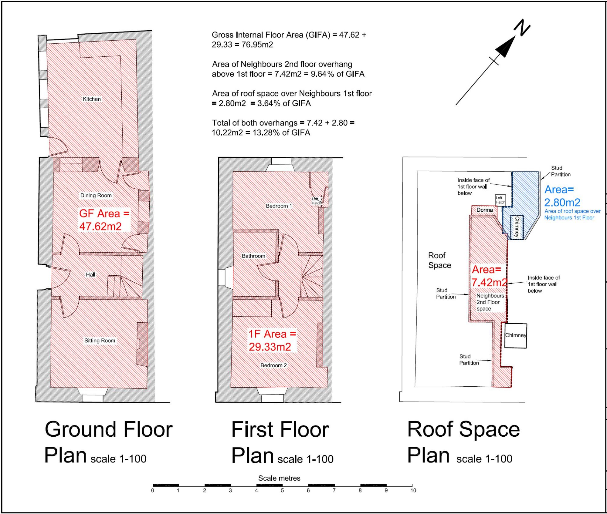
A flying freehold is a term used to describe a situation where the freehold of one property overhangs or underlies another. This is quite a common occurrence with older houses or buildings that have at some point in their life been subdivided. Sometimes the dividing walls chosen for the subdivision at different floor levels don’t match up vertically and the result is a flying freehold. This can cause problems with getting a mortgage on a property and very often the mortgage lender will want to know more details about the extent of the flying freehold and what percentage this represents of the gross internal floor area.
By conducting a fully controlled survey of the floors in a building we are able to provide all the information a mortgage lender or other financial institution would need in order to make a decision on an application.